Some 3,500 years ago on the mainland of Greece, the Mycenaeans began building one of the most powerful state-level societies in the Aegean region. With their rich warrior aristocracy and wide-ranging trade routes, their impact was such that several hundred years after their decline, they became the subjects of Homer’s great epic poems. However, little is known about how this sophisticated civilization rose in power and why it abruptly fell. The discovery of the first positively identified Mycenaean harbor and port town by Thomas Tartaron, Assistant Professor of Classical Studies, and his colleagues promises valuable answers to some of these mysteries.
In 2001, Tartaron and Daniel J. Pullen of Florida State University, as part of the Eastern Korinthia Archaeological Survey project , combed hundreds of miles of shoreline looking for signs of ancient harbors — key to understanding Mycenaean expansion and trade.
“One of the things we don’t understand about the Mycenaeans is where the harbors were that goods were moving in and out of,” Tartaron says. “This is because Greece is very tectonically active and so much of the coastline has changed.”
Located on the Saronic Gulf along an isolated stretch of Greece’s eastern shoreline, Tartaron and Pullen discovered ruins of a settlement they named Korphos-Kalamianos. In this rare instance, soil erosion and tectonic activity worked for rather than against the researchers and actually helped reveal the site. Although a portion of Kalamianos is now submerged in the Gulf, remains of about 20 acres of closely built structures are plainly visible. Tartaron says, “It has all collapsed, but by carefully looking, you can still make out the lines of the walls.”
Located on the Saronic Gulf along an isolated stretch of Greece’s eastern shoreline, Tartaron and Pullen discovered ruins of a settlement they named Korphos-Kalamianos. In this rare instance, soil erosion and tectonic activity worked for rather than against the researchers and actually helped reveal the site. Although a portion of Kalamianos is now submerged in the Gulf, remains of about 20 acres of closely built structures are plainly visible. Tartaron says, “It has all collapsed, but by carefully looking, you can still make out the lines of the walls.”
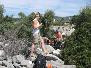
Research on Kalamianos is part of Saronic Harbors Archaeological Research Project (SHARP), led by Tartaron and Pullen. The interdisciplinary team works with a permit from Greece’s Ministry of Culture and operates under the auspices of the American School of Classical Studies at Athens. Last summer, Tartaron, Pullen, and a research team including Penn graduate and undergraduate students, returned to Kalamianos and produce a detailed map of all the buildings on the site using differential global positioning system technology. They also analyzed the layout and construction techniques of the buildings and surveyed for artifacts on the site and in the surrounding countryside. This May, Tartaron will return with another team for fieldwork primarily focused on completing the intensive exploration of the territory around Kalamianos, and working out details of the coastline’s configuration in Mycenaean times.
SHARP’s work has already revealed details about Kalamianos that provide important clues to the beginnings of the Mycenaean expansion. For example, approximately 100 to 200 meters off the shoreline, the shallow and rocky underwater surface drops off into a deep area rich with marine life that locals call “the chasm.” Tartaron conjectures that when Kalamianos was established, the shoreline may have abutted this area, making for an ideal harbor that was both resource rich and allowed for a deep-water approach by ships.
Kalamianos may have been the product of political motives as well. The researchers discovered that the settlement’s structures were built on a grid-like pattern, and they found remains of a fortification wall around its landward side. Over the Gulf, Kalamianos directly faced the island of Aegina, on which another influential settlement, Kolonna, was located. This evidence suggests that Kalamianos was planned and possibly built with a military or naval purpose.
Evidence collected by Tartaron and his colleagues dates the settlement between 1,400 and 1,200 B.C., a time when Mycenae, the greatest Mycenaean city, was rapidly expanding eastward toward Kalamianos and the Saronic Gulf. Also around 1,400 B.C., Tartaron explains, imports from Kolonna start diminishing at sites all around the region, and Mycenaean imports from Mycenae and surrounding areas start increasing.
“The territory between Mycenae and Kolonna may have been a contested periphery,” Tartaron says. “Kalamianos may have served as a kind of a symbolic gesture that said, ‘We are Mycenae, we’re here, and now we’re in charge.’ ”
The shifting nature of political states — how they expand, compete and consolidate — has always been integral to human society, and the universal nature of this issue inspires Tartaron to explore its earliest incarnations. “I’ve tried to use archaeology and other fields like geology and geomorphology to figure out how political settlements work,” Tartaron says. “In other words, how are people and societies connected?”
Tartaron’s research on Kalamianos also allowed him to make an unexpectedly local connection. “One of the things that has been really rewarding and that I didn’t anticipate is how excited the local community is about this,” he says. “In a way this work has transformed from what is my research agenda to something totally new – and that is helping the communities there recover their Mycenaean heritage.”